



Jiwar
Municipal reports and field operations, from a citizen photo to a verified fix
-
At a glance
Sector
Government & municipalities
Platforms
Web · iOS · Android · WhatsApp
Modules
9
Integrations
8
Screens
4
Total duration
24 weeks
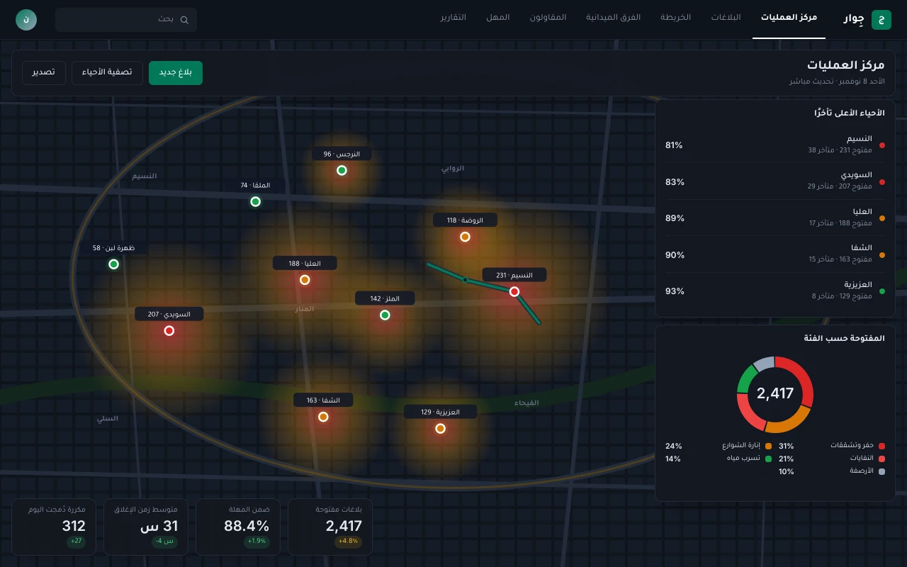
Jiwar takes citizen reports from the app, WhatsApp and web with a photo and a location resolved to the National Address. AI classifies the photo and the text, merges nearby duplicates and routes each report to the right department or contractor, with an SLA set for its category. Field crews work from their own app with before-and-after evidence, citizens rate the fix, and leadership follows a live district heat map, SLA compliance and contractor performance.
-
Challenge
-
01
One issue is reported dozens of times across channels, causing repeat site visits and scattered crew effort.
-
02
Triage and routing are manual: staff read each description and pick an owner, so reports bounce between departments and contractors for days.
-
03
There is no verified proof of work: reports close without an after photo, and citizens report the same issue again.
-
04
Leadership has no live view of districts or of each contractor against its contract, so decisions rest on late monthly reports.
Who it is built for
-
Citizen or resident
Reports in under a minute with a photo and location, and knows when it will be fixed
-
Operations centre agent
Reports already classified, clustered and routed, ready to confirm
-
Department or contractor supervisor
A prioritised task list with a deadline for every report
-
Field crew
A daily route, the exact spot and before-and-after evidence from the phone
-
Executive leadership
A live district map, SLA compliance and contractor performance
-
Modules
What the system does
Connected modules working on one set of data.
-
01
Omnichannel intake
App, WhatsApp, web and call centre in one inbox, with photo, location and National Address
-
02
AI triage
Classifies photo and text, rates severity and proposes the owner
-
03
Duplicate clustering
Groups similar nearby reports under one master and updates every reporter
-
04
Routing & SLAs
Routing by category, district and contract zone, with an SLA per category and severity and automatic escalation
-
05
Field crew app
Daily tasks and navigation, geotagged before-and-after photos, works offline
-
06
Contractor management
Contract zones, SLAs and penalties, with work verified before each payment certificate
-
07
GIS & heat maps
Heat maps by district and category, with asset layers such as light poles
-
08
Citizen feedback
A rating after closure, and reopening when the issue is not resolved
-
09
Executive dashboard
SLA compliance, backlog, department and contractor performance, with periodic reports
Where the AI works
-
AI · 01
A vision model classifies the report photo (pothole, broken street light, waste, water leak, damaged sidewalk), rates severity and rejects unusable photos.
-
AI · 02
An Arabic language model reads descriptions written in local dialects and extracts the category and risk cues such as "near a school" or "constant leak".
-
AI · 03
Duplicate detection combines distance, category, time and image similarity, attaching a new report to an open one instead of opening a new task.
-
AI · 04
Before-and-after photo comparison verifies the work before closure, and a forecast of report volume by district and season helps plan crews.
-
Screens
The system as the client's team and customers use it.
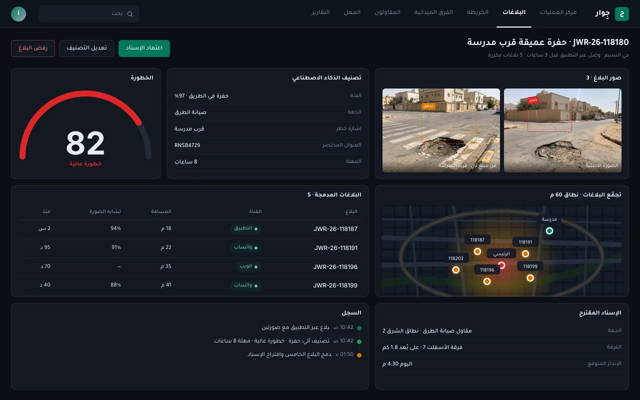
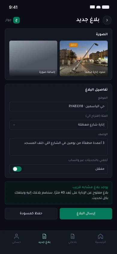
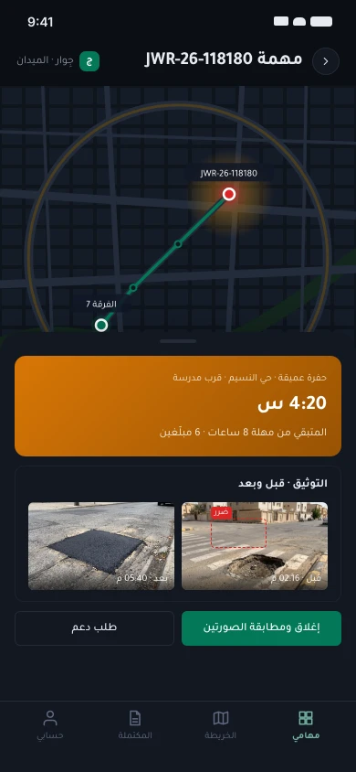
-
Architecture
Independent services, in-Kingdom data, and integrations over documented APIs.
Channels
- Citizen app: iOS & Android
- WhatsApp bot: Reports with photo & location
- Web & call centre: Web form & call centre
- Field crew app: Offline, before & after photos
- Ops console: Operations & leadership
Edge
- API gateway: Rate limits & WAF
- Identity: Nafath, roles & contract zones
Services
- Intake service: Report intake & normalisation
- Routing & SLA: Routing, SLAs & escalation
- Work orders: Tasks, contractors & completion
- Geo service: Addresses, districts & maps
- Notifications: WhatsApp, SMS & push
AI
- Photo classifier: Category, severity & before/after check
- Arabic text model: Descriptions in local dialects
- Duplicate detector: Distance, time & image similarity
Data
- PostgreSQL · PostGIS: Reports, points & districts
- Kafka: Report events
- Object storage: Photos, in-Kingdom
Integrations
- Nafath: National SSO
- SPL National Address: National & short address
- Balady: Report sync where applicable
- Esri ArcGIS: District & asset layers
- Contractor systems: Work orders & completion
Connections
- Citizen app to API gateway
- WhatsApp bot to API gateway
- Web & call centre to API gateway
- Field crew app to API gateway
- Ops console to API gateway
- API gateway to Identity
- API gateway to Intake service: REST
- API gateway to Work orders
- Intake service to Photo classifier
- Intake service to Arabic text model
- Intake service to Duplicate detector
- Intake service to Geo service
- Intake service to Routing & SLA
- Routing & SLA to Work orders
- Work orders to Notifications
- Work orders to Photo classifier: after photo
- Intake service to PostgreSQL · PostGIS
- Intake service to Kafka: events
- Intake service to Object storage
- Identity to Nafath
- Geo service to SPL National Address
- Geo service to Esri ArcGIS
- Intake service to Balady: sync
- Work orders to Contractor systems: API
Stack
- Next.js
- NestJS
- Flutter
- PostgreSQL · PostGIS
- Kafka
- MapLibre
- Python · PyTorch
- Kubernetes
-
Workflow
Report lifecycle
-
01
Report with photo and location
CitizenApp · WhatsApp · Web
-
02
Identity and address
AutomaticNafath · SPL National Address
-
03
Classify and rate severity
AutomaticPhoto classifier · Arabic text model
-
04
Detect and merge duplicates
AutomaticDuplicate detector
-
05
Route and set the SLA
AI, then operations centreRouting & SLA
-
06
Assign a crew or contractor
SupervisorWork orders · Contractor systems
-
07
Fix with before-and-after evidence
Field crewField crew app
-
08
Verify and close
AI, then supervisorPhoto classifier
-
09
Notify and collect a rating
CitizenWhatsApp · App · Balady
-
Data & API
The core entities and relations, and a live example from the API.
Report
- iduuidPK
- codetextunique
- channelenum(app,
whatsapp, web, call) - category_iduuidFK
- district_iduuidFK
- locationgeography(Point)
- national_addresstext
- cluster_iduuidFK
- statusenum
Cluster
- iduuidPK
- master_report_iduuidFK
- category_iduuidFK
- severitysmallint
- centroidgeography(Point)
- reports_countint
- sla_due_attimestamptz
Category
- iduuidPK
- name_artext
- department_iduuidFK
- sla_hourssmallint
- severity_rulesjsonb
District
- iduuidPK
- name_artext
- city_codetext
- boundarygeography(Polygon)
- contract_zone_iduuidFK
WorkOrder
- iduuidPK
- cluster_iduuidFK
- assignee_typeenum(crew,
contractor) - assignee_iduuid
- due_attimestamptz
- statusenum
- closed_attimestamptz
Evidence
- iduuidPK
- work_order_iduuidFK
- kindenum(before,
after) - storage_keytext
- taken_attimestamptz
- locationgeography(Point)
- match_scorereal
Contractor
- iduuidPK
- nametext
- cr_numbertext
- contract_notext
- zone_idsuuid[]
- penalty_rulesjsonb
Feedback
- iduuidPK
- report_iduuidFK
- ratingsmallint
- commenttext
- reopenedboolean
- attimestamptz
- Category 1—∞ Report
- District 1—∞ Report
- Cluster 1—∞ Report
- Cluster 1—1 WorkOrder
- Contractor 1—∞ WorkOrder
- WorkOrder 1—∞ Evidence
- Report 1—1 Feedback
/v1/reports
Open a report from any channel
Request
{
  "channel": "app",
  "reporter": { "nafath_sub": "nfd_7Q2K9", "mobile": "+9665•••••381" },
  "location": { "lat": 24.7368, "lng": 46.8225, "accuracy_m": 6 },
  "description": "Large pothole in front of the school gate; cars are swerving around it",
  "photos": ["upl_91c2", "upl_91c3"]
}
Response
{
  "id": "rpt_01JD4R8W2M",
  "code": "JWR-26-118180",
  "status": "routed",
  "classification": {
    "category": "pothole",
    "confidence": 0.97,
    "severity": "high",
    "risk_cues": ["near_school"]
  },
  "national_address": { "short": "RNSB4729", "district": "Al Naseem" },
  "duplicate_of": null,
  "assigned_to": { "type": "contractor", "zone": "EAST-2" },
  "sla_due_at": "2026-11-08T18:42:00+03:00",
  "tracking_url": "/t/118180"
}
Webhook event · report.closed
{
  "event": "report.closed",
  "cluster": "CLS-26-020931",
  "master": "JWR-26-118180",
  "reporters_notified": 6,
  "closed_by": "crew_asphalt_7",
  "after_photo_match": 0.93,
  "within_sla": true,
  "at": "2026-11-08T16:24:10+03:00"
}-
Integrations
-
Nafath
Citizen sign-in with the national SSO
-
SPL National Address
Coordinates to National Address and short address
-
Balady
Report and status sync with the Balady platform where applicable
-
WhatsApp Business
Intake with photo and location, plus status updates
-
Esri ArcGIS
District and asset layers and heat maps
-
Contractor systems
Work orders out and completion back over API
-
Call centre (CTI)
Phone reports opened with caller details
-
SMS gateway
Text updates for people without the app
-
Security & compliance
- Data and photos hosted inside the Kingdom, in line with government data classification.
- National Cybersecurity Authority Essential (ECC) and Cloud (CCC) Cybersecurity Controls.
- Personal Data Protection Law (PDPL) alignment: faces and number plates blurred automatically before photos are shown.
- Reporter identity and number are never shown to contractors or field crews.
- Role- and zone-based access: each contractor sees only the reports in its contract zone.
- Encryption in transit and at rest with managed keys.
- Immutable audit trail for every assignment, status change and closure.
-
Delivery plan
Clear phases with measurable deliverables.
-
01
Discovery & process mapping
- Workshops with the operations centre, technical departments and contractors
- Inventory of categories, SLAs and contract zones
3 weeks -
02
UX & architecture
- Citizen and crew app prototypes tested in the field
- Spatial data, routing and API design
3 weeks -
03
MVP build
- Omnichannel intake, routing and SLAs
- Citizen app, crew app and operations console
8 weeks -
04
Integrations & GIS
- Nafath, National Address, Balady and WhatsApp
- District and asset layers and contractor systems
4 weeks -
05
Model training & pilot
- Train photo and text models on labelled historical reports
- Pilot in a small set of districts
4 weeks -
06
Go-live & hypercare
- Phased launch by district and category
- Training for field crews and the operations centre
2 weeks
- Total duration
- 24 weeks
- Team
- Project manager, business analyst, UX designer, a GIS engineer, 3 backend and frontend engineers, 2 mobile engineers, an ML engineer, QA and DevOps.
Performance
- < 2 min Automatic triage and routing
- 85%+ Duplicates caught before assignment
- 100% Reports closed with an after photo
- 99.9% Availability